3D Aerial View Rendering Services
Are you looking to elevate your projects with stunning aerial views? Our 3D aerial view rendering service might be just what you need.
From architectural designs to real estate listings, these services offer a unique perspective that can bring your vision to life.
In this article, we will explore what aerial view rendering is, the benefits it offers, the different types of services available, how it is used in various industries, the steps involved in the rendering process, and how to choose the right service provider.
What Are 3D Aerial View Rendering Services?
3D Aerial View Rendering Services encompass the creation of high-quality visuals and virtual tours using innovative techniques to provide clients with opulent rendering solutions.
Utilizing cutting-edge technology, Opulent 3D Studio excels in delivering tailored architectural visualizations that bring projects to life in stunning detail. With digital rendering expertise, the studio transforms concepts into realistic images, offering clients a glimpse into the future of their designs. These customized solutions cater to the specific requirements of each project, ensuring that every aspect is carefully crafted to meet the client’s vision and exceed expectations.
What Is Aerial View Rendering?
Aerial view rendering involves the use of 3D modeling and drone technology to capture stunning aerial photography, providing unique perspectives for architectural visualization and real estate development projects.
The process of aerial view rendering begins with creating a digital 3D model of the architectural design. This model serves as the foundation for the rendering, allowing designers to experiment with different perspectives and angles.
Once the model is ready, drones equipped with high-resolution cameras are used to capture aerial images of the site. These images provide detailed views from various heights, capturing the intricacies of the design and surrounding environment. The integration of aerial photography enhances the visual representation, offering clients and stakeholders a more immersive experience of the proposed project.
What Are The Benefits Of 3D Aerial View Rendering?
The benefits of 3D Aerial View Rendering include enhancing real estate development projects with high-quality visuals that offer detailed insights into exterior and interior design elements, contributing to effective property marketing strategies.
This advanced rendering technique provides a birds-eye perspective, giving potential buyers a realistic vision of the property layout and surrounding landscapes. With 3D Aerial View Rendering, developers can showcase the property’s proximity to amenities, green spaces, and other important features, attracting a wider audience.
The professional rendering helps in visualizing different design options, allowing for quick modifications and decision-making during the planning stages. By integrating aerial views into property marketing materials, stakeholders can present a compelling narrative that differentiates their projects in a competitive market.
What Are The Different Types Of 3D Aerial View Rendering Services?
Various types of 3D Aerial View Rendering Services cater to distinct sectors such as architectural visualization, landscape architecture, and real estate, offering customized solutions for rendering projects.
- Architectural visualization through 3D aerial view rendering services helps architects, designers, and developers to visualize their projects in a realistic and immersive manner. These services focus on showcasing exterior design details with precision, allowing stakeholders to make informed decisions during the design and construction phases.
- In landscape architecture, 3D aerial view renderings provide a comprehensive overview of how outdoor spaces will look once completed, aiding in the planning and design process.
- In real estate, these renderings play a pivotal role in property marketing strategies, attracting potential buyers by presenting properties in their best light.

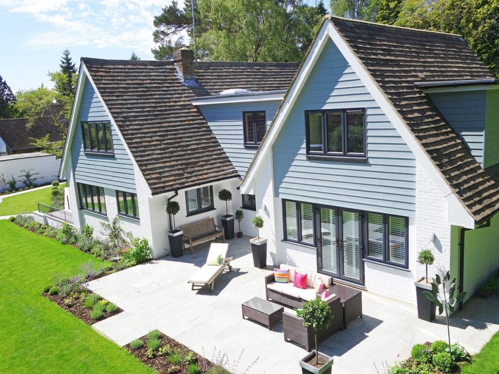
Architectural Aerial View Rendering
Architectural Aerial View Rendering specializes in transforming building projects into photorealistic renderings, emphasizing exterior design elements and structural details through innovative rendering techniques.
By utilizing advanced software and cutting-edge technology, these renderings offer a realistic representation of proposed developments, enabling clients to visualize the final product before construction even begins. Architectural Aerial View Rendering pays meticulous attention to detail, capturing intricate design features such as facades, landscaping, and materials with precision. The ability to showcase building projects from a bird’s eye view provides a unique perspective that aids in decision-making and marketing efforts for architects, developers, and stakeholders alike.
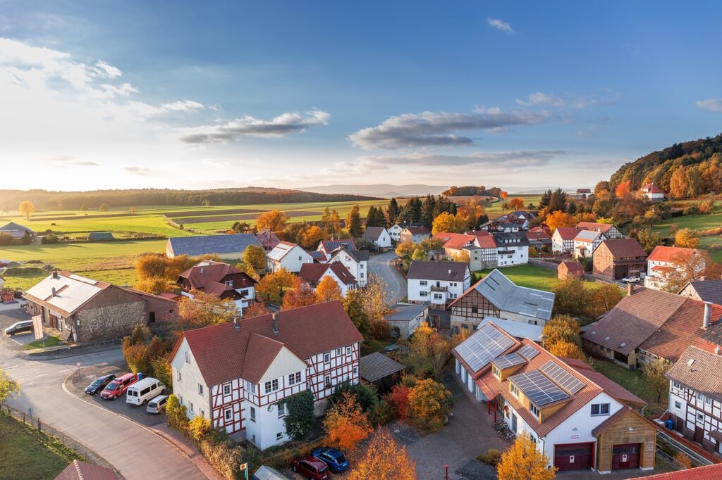
Landscape Aerial View Rendering
Landscape Aerial View Rendering employs topographic mapping and drone technology to support urban planning initiatives, providing detailed aerial views for landscape architecture projects.
This innovative approach to landscape design leverages the power of geographic information systems to analyze terrain, proposed land use, and potential environmental impacts. By utilizing drone technology, urban planners and landscape architects can capture precise data that allows for more informed decision-making when designing green spaces, parks, and infrastructure.
The integration of topographic mapping in aerial view rendering ensures accuracy in depicting elevations and slopes, assisting in the creation of sustainable and functional landscapes that blend seamlessly with their surroundings.
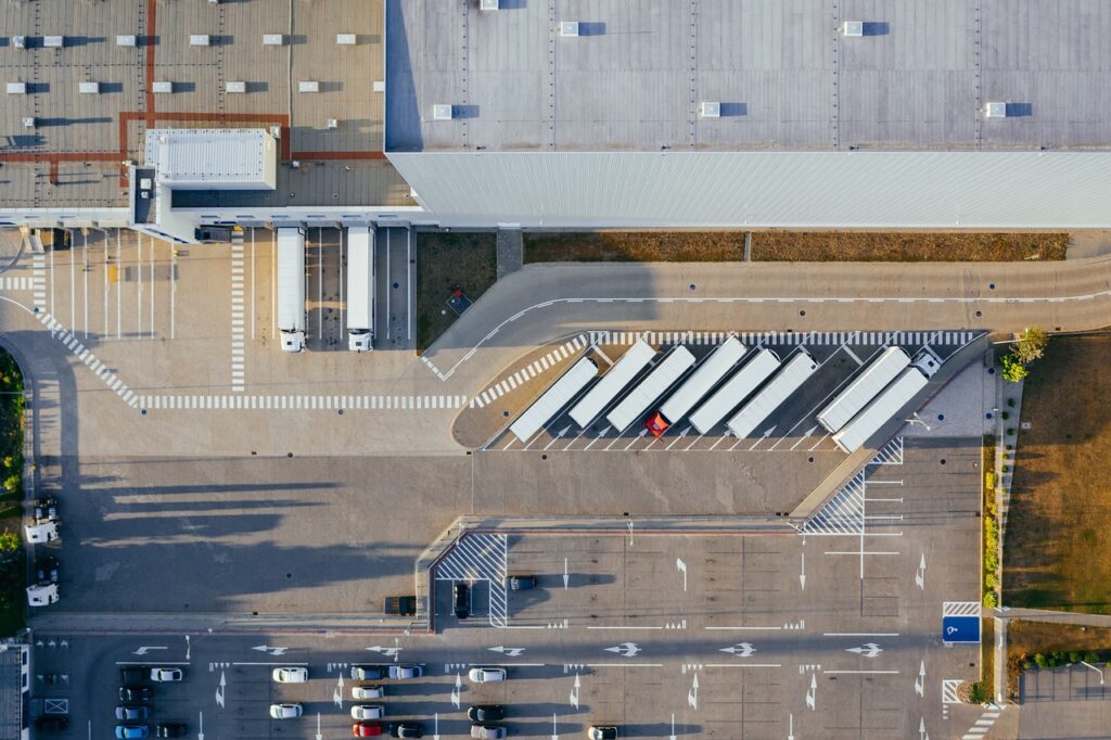
Industrial Aerial View Rendering
Industrial Aerial View Rendering showcases perspective views of industrial sites with a focus on structural design elements, offering unique insights for industrial projects and site analysis.
This specialized form of visualization allows stakeholders in industrial projects to gain a comprehensive understanding of the layout and spatial organization of structures from a bird’s eye view. By highlighting key features such as building placement, road networks, utilities, and surrounding landscapes, industrial aerial view rendering aids in decision-making processes related to construction, expansion, and renovation projects. These detailed renderings help identify potential challenges and opportunities within the industrial site, contributing to more efficient planning and development strategies.
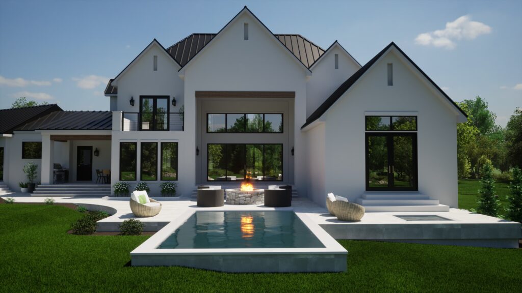
Real Estate Aerial View Rendering
Real Estate Aerial View Rendering plays a pivotal role in property marketing by delivering professional rendering services that elevate the visual representation of real estate developments and enhance property marketing strategies.
The utilization of Real Estate Aerial View Rendering has become increasingly essential in today’s competitive property market. This advanced technology provides potential buyers with a comprehensive and detailed overview of a property, allowing them to visualize the layout, design, and surrounding environment before physically visiting the site.
By offering virtual tours through aerial view rendering, real estate agents and developers can attract more interested buyers and investors, ultimately leading to quicker sales and increased property exposure. This innovative tool has revolutionized the way properties are marketed, providing a unique selling point in an ever-evolving industry.
How Is 3D Aerial View Rendering Used In Different Industries?
The application of 3D Aerial View Rendering Service extends across diverse industries such as architecture, real estate, urban planning, and tourism, leveraging modern technology to meet client requirements and industry standards.
Architectural visualization plays a crucial role in utilizing 3D Aerial View Rendering to present projects in a visually appealing manner before their actual construction. Real estate developers use project visualization to showcase properties from a unique perspective, giving potential buyers a realistic preview.
In urban planning, this technology aids in illustrating future city layouts, infrastructures, and development projects. The tourism sector benefits from enhanced virtual tours through 3D aerial views, attracting visitors with immersive experiences of destinations.
Architecture
In architecture, 3D Aerial View Rendering offers a detailed approach to project visualization, providing unique perspectives on structural design elements and spatial relationships through high-quality visuals.
Architectural visualization through 3D Aerial View Rendering allows designers and clients to better understand the scale, form, and context of a project. By employing innovative techniques such as realistic lighting effects and material textures, this rendering method brings life to conceptual ideas. It enables stakeholders to visualize the final outcome before construction begins, fostering effective communication and informed decision-making. The ability to showcase the project from different angles aids in highlighting design features and evaluating the overall composition for optimal aesthetics and functionality.
Real Estate
In real estate, 3D Aerial View Rendering caters to customer requirements by ensuring quality assurance in visual representations, aiding in property marketing efforts and delivering cost-effective solutions.
The utilization of 3D Aerial View Rendering plays a pivotal role in enhancing property marketing strategies through providing prospective buyers with a comprehensive and immersive view of the property. By leveraging sophisticated image processing techniques, the rendering transforms traditional 2D visuals into dynamic 3D perspectives that engage and captivate potential clients. This innovative approach not only helps to showcase the property’s unique features and design elements effectively but also sets it apart in a competitive market landscape. By offering cost-effective solutions, 3D Aerial View Rendering enables real estate professionals to optimize their resources and achieve better return on investment.
Urban Planning
Urban Planning benefits from 3D Aerial View Rendering by incorporating geographic information systems and adhering to zoning regulations, facilitating precise mapping for urban development projects.
This innovative approach enables urban planners to visualize the environment from multiple angles, providing a comprehensive understanding of the city landscape. By integrating 3D Aerial View Rendering, authorities can accurately assess potential land use within zoning boundaries, ensuring efficient utilization of space. The precision mapping capabilities contribute to detailed infrastructure planning, helping to streamline construction processes and optimize resource allocation. This technology plays a pivotal role in ensuring sustainable urban development by offering insights that were previously challenging to obtain through traditional planning methods.”
Tourism
In the tourism sector, 3D Aerial View Rendering showcases the environmental impact of destinations and offers captivating virtual tours that enhance the visitor experience and marketing materials.
This innovative technology allows tourists to explore various destinations from a bird’s eye view, giving them a unique perspective of the landscapes and attractions. By providing detailed and realistic simulations, 3D Aerial View Rendering enables businesses in the tourism industry to create compelling presentations for potential visitors. The ability to visualize destinations in high detail through these renderings helps in promoting tourism initiatives and showcasing the beauty of different locations, ultimately attracting more interest and engagement from travelers.
What Are The Steps Involved In 3D Aerial View Rendering?
The process of 3D Aerial View Rendering includes gathering data, creating digital models, adding details, and finalizing images using modern technology to achieve project visualization aligned with client satisfaction and industry standards.
The initial step in 3D Aerial View Rendering involves the collection of relevant data such as geographical information, building layouts, and environmental factors. This data serves as the foundation for the digital model creation, where skilled digital artists use specialized software to construct a three-dimensional representation of the project area.
Once the basic model is in place, detailed elements like roads, vegetation, and landmarks are added to enhance realism and accuracy. Subsequently, the rendering process takes place, leveraging a render farm for efficient computation and high-quality output. The final images are refined, ensuring they meet the client’s requirements and exceed industry standards.
Gathering Data and Information
The initial stage in 3D Aerial View Rendering involves gathering data and information through drone mapping techniques, followed by detailed image processing to enhance the quality of visuals.
This data collection process using drone technology plays a crucial role in capturing high-resolution images from various angles and heights. By utilizing advanced drones equipped with cameras, professionals can gather precise data points that are essential for creating a realistic 3D model. The image processing techniques involve stitching together multiple images, applying filters for color enhancement, and removing distortions to produce a visually appealing and accurate representation of the landscape or structure being rendered.
Creating a Digital Model
Creating a digital model in 3D Aerial View Rendering involves utilizing software tools and animation services to develop a comprehensive representation of the project, setting the foundation for detailed visualizations.
These 3D modeling software tools play a crucial role in shaping the virtual landscapes and structures, allowing for precise design elements to be incorporated seamlessly. Through the integration of visual effects, the digital model can be brought to life, adding realism and depth to the presentation. Animation services further enhance the project by creating dynamic movement within the 3D aerial view, offering a complete and immersive experience for stakeholders and clients to visualize the final outcome.
Adding Details and Textures
Adding intricate details and textures in 3D Aerial View Rendering relies on the expertise of a creative team that adheres to project deadlines, ensuring the incorporation of innovative techniques for enhanced visual representations.
The collaborative effort within the creative team plays a crucial role in achieving a high-quality professional rendering. Team members bring their unique skills and perspectives together to create realistic landscapes and structures. Efficient communication and brainstorming sessions help in exploring new ideas and implementing cutting-edge technologies.
Meeting project deadlines is paramount, as it ensures timely delivery to clients and allows for necessary revisions and improvements. By staying updated on the latest trends and software advancements, the team continuously refines its approach to maintain a competitive edge in the industry.
Finalizing and Rendering the Image
The final step in 3D Aerial View Rendering involves finalizing and rendering the image to produce high-quality visuals that align with client requirements, offering cost-effective solutions and supporting the creation of impactful marketing materials.
During this phase, experts meticulously refine every detail of the 3D aerial view, ensuring that the final product meets the client’s vision. The rendering services play a crucial role in bringing the project to life, enhancing realism and depth. By integrating advanced technology and techniques, the rendering team can create visually stunning images that captivate audiences. These marketing materials serve as powerful tools for showcasing the project’s potential and attracting stakeholders. The strategic use of lighting, shadows, and textures further enhances the realism of the final render, making it a valuable asset for promotional campaigns.
How To Choose The Right 3D Aerial View Rendering Service Provider?
Selecting the ideal 3D Aerial View Rendering Service Provider involves assessing their experience, expertise, portfolio, and samples to ensure they align with client requirements and project deadlines and Opulent 3D Studio meets all of these requirements.
- When considering technical expertise, it’s crucial to evaluate the provider’s proficiency in the latest rendering software and technologies. A strong understanding of 3D modeling, texturing, lighting, and animation capabilities is paramount for delivering high-quality aerial views.
- Quality assurance should also be a key factor in your decision-making process. Look for providers who have a rigorous quality control process in place to ensure that the final renders meet the highest standards.
- By thoroughly reviewing a potential provider’s past projects and client testimonials, you can gain valuable insights into the quality of their work and their ability to meet and exceed expectations.
Experience and Expertise
Evaluating the experience and expertise of a 3D Aerial View Rendering Service Provider involves assessing their proficiency in utilizing software tools, delivering customized solutions, and adhering to industry standards for optimal project outcomes.
This proficiency in software tools is crucial as it ensures that the provider can effectively manipulate and enhance aerial views to create detailed and realistic renderings. Their ability to offer customized solutions tailored to specific project requirements showcases their technical expertise and flexibility. Adhering to industry standards not only guarantees a high-quality output but also ensures compliance with regulations and guidelines, cementing the provider’s reputation for delivering reliable and professional services.
Portfolio and Samples
Reviewing the portfolio and samples of a 3D Aerial View Rendering Service Provider offers insights into their capabilities, quality standards, and the visual impact of their projects, including high-resolution images and virtual tours.
By analyzing these visuals and presentation materials, clients and stakeholders can gauge the provider’s level of expertise in creating realistic and immersive 3D environments. The quality of the renders can determine the professionalism and attention to detail of the service provider, giving a glimpse into their craftsmanship and design precision. Assessing the portfolio allows potential clients to envision how their own projects could benefit from such high-quality visuals, ensuring that the provider aligns with the desired aesthetics and standards for a successful collaboration.
Customer Reviews and Testimonials
Customer reviews and testimonials provide valuable insights into the level of customer satisfaction offered by a 3D Aerial View Rendering Service Provider, highlighting their image processing capabilities and attention to detail.
These reviews act as a compass for potential clients, guiding them towards providers known for delivering realistic simulations and high-quality outputs. Clients often emphasize how the rendered images closely mirror the actual landscapes, buildings, and environments. This level of precision showcases the service provider’s commitment to creating accurate and visually stunning 3D aerial views.
By focusing on these testimonials, individuals can make informed decisions, ensuring that they choose a provider capable of exceeding their expectations and bringing their projects to life through exceptional rendering services.
Pricing and Turnaround Time
Considering the pricing and turnaround time of a 3D Aerial View Rendering Service Provider is essential to ensure project deadlines are met without compromising quality, emphasizing the balance between cost-effective solutions and quality assurance.
By carefully assessing the cost structures and estimated delivery timelines offered by various service providers, one can make informed decisions that align with the project’s timeline and budget constraints. It is crucial to weigh the pricing against the level of detail and accuracy provided in the 3D aerial renderings.
Seeking testimonials or reviews from past clients can offer valuable insights into the turnaround efficiency and the provider’s commitment to meeting deadlines. This evaluation process plays a pivotal role in selecting a reliable partner for your 3D aerial view rendering needs.
Frequently Asked Questions
3D Aerial View Rendering Services involve creating realistic and accurate 3D visualizations of a project or location from an aerial perspective. It uses specialized software to generate detailed images that give a bird’s eye view of the area.
Opulent 3D Studio is a skilled and experienced provider of 3D Aerial View Rendering Services. By using their services, you can showcase your project in a realistic and visually appealing manner, which can help attract potential clients and investors.
Any project that involves a large area, such as real estate developments, urban planning, or large-scale construction projects, can benefit from 3D Aerial View Rendering Services. It can also be used for marketing purposes, such as showcasing a resort or tourist destination.
Yes, Opulent 3D Studio works closely with their clients to understand their project needs and create a customized 3D aerial view that accurately represents the project. They also offer multiple revisions to ensure the final product meets the client’s expectations.
The timeline for a 3D Aerial View Rendering project can vary depending on the size and complexity of the project. However, Opulent 3D Studio strives to deliver high-quality renderings within a reasonable timeframe and will provide an estimated timeline at the start of the project.
3D Aerial View Renderings can be easily incorporated into project presentations, whether it’s a digital presentation or a physical one. Opulent 3D Studio provides high-resolution images and video files that can be easily inserted into presentations and can even create interactive 3D models for a more engaging presentation.
Stay Connected with Opulent 3D Studio
Follow Opulent 3D Studio on our social media platforms. Stay updated with our recent projects and industry insights. Find us on: